US President John F. Kennedy said of global problems back in 1962: "Forget about oil, think about water". He was right. Indeed, in the 1960s, Lake Aral began to dry up. Half a century has passed, but the problem has not lost its relevance. The fate of the Aral Sea may now be repeated by Lake Balkhash. These are warnings of international experts, not ours.
Scientists warn that the "Aral Sea Syndrome" can be observed in other parts of the world. After all, the main reason for the disappearance of the Aral Sea is man-made, environmental disasters associated with irrigation water channels. The main rivers in Central Asia are transboundary, so there is competition between irrigated agriculture and natural ecosystems. It is for this reason that the ecological problem in the Balkhash delta grows with increasing economic importance. Even the United Nations has confirmed that the lake is under threat of extinction. The main reason why we are concerned is the reduction of the flow of rivers flowing into Balkhash. We all know that when water resources are used inefficiently, the water level in the channels decreases. And the production waste from the mining and smelting plant aggravates the situation even more. These issues are being studied by the Al-Farabi Center for Remote Sensing of the Earth, which has the capability to conduct ground-space monitoring of water resources using remote sensing. The centre can identify and assess the consequences of emergencies and related phenomena. It implements combined geo-information system technology.
The toxicological profile of Lake Balkhash can be seen in the sediments of heavy metals flowing in the rivers, as well as in the waste products of industrial enterprises. Micronutrients are indicators of water quality and pollution. Due to their migratory activity, they have a significant influence on the processes of photosynthesis and respiration. They play an important physiological role in the life activity of aquatic organisms and serve as catalysts of redox processes and growth stimulators. Their quantitative and qualitative composition occurs under the combined effect of natural and anthropogenic factors.
And the role of Balkhash town dominates information on the microelement composition of lake biota. Among pollutants, heavy metals represent a serious danger for fauna and flora. After all, metals, unlike organic pollutants, do not decompose and do not disappear. Heavy metals include a group of non-ferrous metals, whose density exceeds that of iron (7.874 g/cm3). These include zinc, lead, tin, manganese, bismuth, copper, mercury, nickel and cadmium. Many of their compounds, especially their salts, are very harmful to the body. They do not degrade when ingested through food, water and air. In kidneys, liver, joints and other parts of the human body they accumulate and pose a health hazard. That's why the heavy metals in the environment must not exceed the established limits," said Gaukhar Batai, a specialist at the Centre for Remote Sensing of the Earth.
Centre representatives studied Lake Balkhash's pollution with heavy metals. The work was based on the Environmental Monitoring Department's fact sheet on the state of the environment in Kazakhstan.
Water pollution in Lake Balkhash is the main site of the problem. After all, if we contain the situation, in a few more years we may not find water that is contaminated. According to a specialist from the centre, the dynamic changes in the water level and area of Lake Balkhash are directly linked to the river. Therefore, an analysis of the river was carried out using satellite images.
- Five rivers flow into the lake. The biggest of these is the Ili River. It provides 80 per cent of the total freshwater flow. The delta ends with the western Balkhash. The Karatal, Aksu, Lepsy and Ayagoz rivers flow into the eastern part of the lake. Their total flow in the lake is 20 per cent. The delta or a total area of 8,000 km2 is the largest natural delta and wetland complex in Central Asia. This river is important for the conservation of natural riparian ecosystems both in the delta and in Lake Balkhash itself. Samples were taken in the villages of Zhideli, Bakanas, Bakanas Bridge, D.Kunayev Bridge, Tamgalytas along the rivers Ili and Karatal flowing into Lake Balkhash. Based on these data, a map of pollution of surface waters in the Balkhash basin by heavy metals has been drawn up. To obtain comparable results, we used data for 2017 and 2020. As a result, it turned out that the amount of heavy metals has increased significantly over the last year. For example, the Tamgalytas tract along the Ili River has exceeded the maximum permissible discharge (MPD) limit for arsenic 1.2. And in the area of Zhideli village 3.1 MPC for arsenic, in the area of D.Kunayev bridge on the Ili River, 3.6 MPC for arsenic exceeds the norm. In the Ushtobe area of the Karatal River, arsenic exceeded the standard by 1.3 MPC and lead by 1.4 MPC," Gaukhar Batay said.
Representatives of the Center studied the pollution of Lake Balkhash with heavy metals. The work was based on the information bulletin of the Department of Environmental Monitoring on the state of the environment in Kazakhstan.
Water pollution in Lake Balkhash is the main site of the problem. After all, if we contain the situation, in a few more years we may not find any water that is contaminated. According to the center's specialist, the dynamic changes in the water level and area of Lake Balkhash are directly linked to the river. Therefore, an analysis of the river was carried out using satellite images.
- Five rivers flow into the lake. The biggest of these is the Ili River. It provides 80 per cent of the total freshwater flow. The delta ends with the western Balkhash. The Kartal, Aksu, Lepsy, and Ayagoz rivers flow into the eastern part of the lake. Their total flow in the lake is 20 per cent. The delta or a total area of 8,000 km2 is the largest natural delta and wetland complex in Central Asia. This river is important for the conservation of natural riparian ecosystems both in the delta and in Lake Balkhash itself. Samples were taken in the villages of Zhideli, Bakanas, Bakanas Bridge, D.Kunayev Bridge, Tamgalytas along the rivers Ili and Karatal flowing into Lake Balkhash. Based on these data, a map of pollution of surface waters in the Balkhash basin by heavy metals has been drawn up. To obtain comparable results, we used data for 2017 and 2020. As a result, it turned out that the amount of heavy metals has increased significantly over the last year. For example, the Tamgalytas tract along the Ili River has exceeded the maximum permissible discharge (MPD) limit for arsenic 1.2. And in the area of Zhideli village 3.1 MPC for arsenic, in the area of D.Kunayev bridge on the Ili river, 3.6 MPC for arsenic exceeds the norm. In the Ushtobe area of the Karatal River, arsenic exceeded the standard by 1.3 MPC and lead by 1.4 MPC," Gaukhar Batay said.
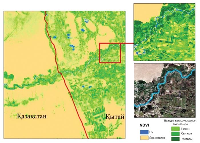
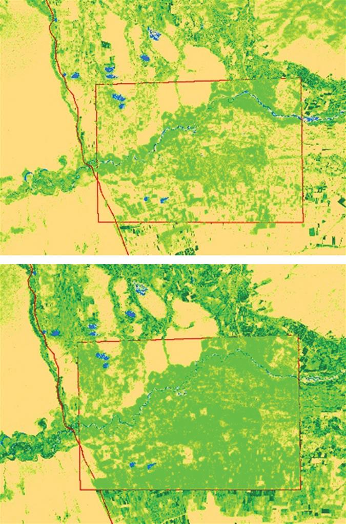
The Ili is a transboundary river originating in China. It has three sources - the Tekes, Kunes, and Kash rivers. The Tekes flow north from Khan-Tengri, while the Kunes and Kash rivers originate from the glaciers of the Tianshan mountains in China. As the main flow of Lake Balkhash spans China and Kazakhstan, its water level, as it decreases, poses a common problem for China and Kazakhstan. In the upper reaches of the river, on the Chinese side, more water is being consumed and, as a result, the water level in the channel is dropping year by year. Scientists note that from 1995 to 2015 the irrigated area on the Chinese side increased by 30%. On the Kazakhstani side, there is no significant change.
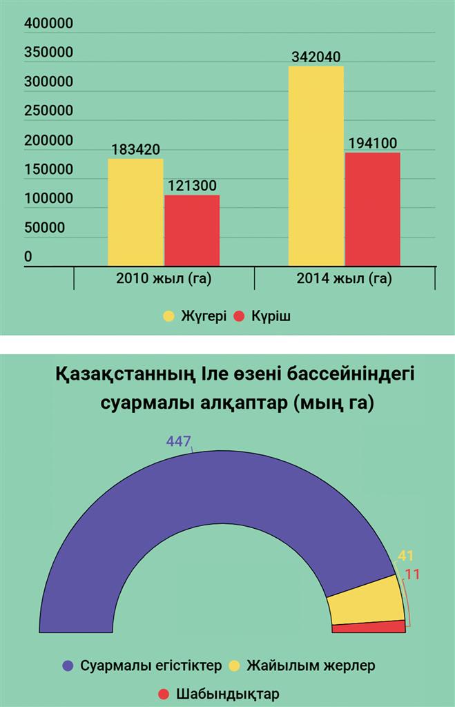
According to Gaukhar Batay, the Chinese border regions of Hoheng, Chapal-Sibosk autonomous county, Kuldjinsk, and Ile-Kazakh autonomous county were taken as an object of study. Cultivated areas of Chinese lands along the Ili River on a total area of about 132 thousand hectares have been counted. As a result, it was found that the sown area in this area in 2018 was 35 thousand hectares, in 2020 - 64 thousand hectares. The Ili River Basin is ideal for agriculture in Xinjiang. In 2014, the sown areas of maize, cotton and rice increased significantly compared with 2010. For example, maize increased from 183,000 ha in 2010 to 342,000 ha in 2014, rice from 121,000 ha in 2010 to 194,000 ha in 2014.
In Kazakhstan, the Ili River basin contains most of Kazakhstan's irrigated land. According to statistics, 447,000 ha are irrigated cropland, 41,000 ha are pastures and 11,000 ha are hayfields. The main crop is wheat. Other important crops are corn, sugar beet, tobacco, fruit, vegetables, and rice.
Kairzhan TUREZHANOV